Grants
Tackling environmental threats
Marine Mapping & Modelling Resources
Three £15,000 grants awarded
Project Duration: October 2021 – June 2024
Grantee: Partnership from Coastal Communities Network
Project Summary: The development of online resources that model and map the environmental impacts of aquaculture
Background:
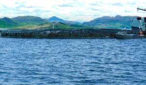
There are concerns at local and national levels over the environmental impacts of the fish farming industry on the West Coast of Scotland. Waste discharge, catastrophic escapes, and high sea lice numbers all threaten the wider marine environment, particularly wild salmon and sea trout populations which have been declining over the last 50 years to critical levels. The Atlantic Salmon is now officially classified as an endangered species by the IUCN. One significant cause of this decline is infestation of sea lice, which originate in fish farms and threaten wild fish as they swim migratory routes from river, to sea, and back to the river.
Sea lice density models can show which areas pose the most risk to wild fish. This can then inform planning decisions for new fish farms, and regulation of existing farms, giving wild fish populations a greater chance of survival.
The Grant
From October 2021 to June 2024, HIEF awarded three grants of £15,000 to a team of modellers who had connected through the CCN – Coastal Communities Network. The three key people involved were John Aitchison, FOSOJ; Tom Scanlon, MTS-CFD; and Julien Moreau, The NW Edge).
Project Activities
Through HIEF funding, the team were able to create complex hydrodynamic models of the West Coast of Scotland, into which sea lice data were inputted. Separately, chemical and pollution data were incorporated into a newly-developed suite of resources called CLAWS.
Phase 1 focussed on developing the hydrodynamic models of the West Coast of Scotland, into which sea lice data began to be inputted. A user-friendly app that displayed this modelled sea lice dispersion was developed, using the Greater Clyde as a ‘test area’ in order to inform planning decisions for new fish farms in the Firth of Clyde.
Phase 2 extended sea lice dispersal maps to cover the whole West Coast of Scotland, including the Outer Hebrides. Simultaneously, dissolved nutrient and waste (faeces) pollution from fish farms was modelled, to demonstrate their damaging effects to local marine environments.
Phase 3 enabled CCN’s modelling to mirror the models being developed by the Scottish Environmental Protection Agency (SEPA) and the aquaculture industry. SEPA has developed and implemented a new regulatory framework that relies on hydrodynamic computational modelling of the dispersion of sea lice, to assess the risk to wild fish.
SEPA’s models are based on a local level approach that needed to be mirrored in CCN’s own sea lice modelling, to enable weaknesses in SEPA’s approach to be challenged robustly. SEPA’s approach includes ‘virtual fish tracking’, to illustrate the likely cumulative risk to wild fish as they traverse routes to the open sea. This grant enabled CCN to develop a similar fish tracking approach.
SEPA models only consider cumulative risk within limited Wild Salmonid Protection Zones & it assumes there is no risk outside these zones, whereas CCN’s modelling show the cumulative risk for fish migrating up the whole west coast of Scotland.
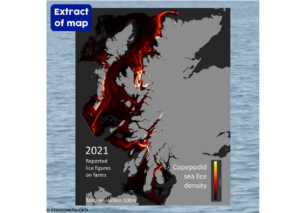
End result
The map below shows an extract of the CCN Mapping and Modelling resource. Sea lice data from all the active salmon farm sites, between 2004-2021 is visible on the resource – allowing comparisons between different years and production cycles. The model is methodologically aligned to SEPA’s, allowing weaknesses in both models and the proposed regulations to be challenged before they were set in stone.
Impact
Fish farm objections
Several community groups, particularly in the Greater Clyde area, were able to make use of the modelling to object to the impacts of new fish farm applications in their local area.
In Loch Hourn, the community were able to use these modelling resources (in connection to a project part funded by HIEF) to object to a planned fish farm expansion, which would increase the pressure on wild fish. While this was eventually overturned through an appeal by MOWI, the initial rejection serves as an important planning precedent for future fish farm applications to consider wild fish impacts.
In the Kilbrannan Sound (on the West side of Arran), a fish farm received planning permission on the condition that it will not contain fish for part of the production cycle. This meant that the farm would add no more sea lice to the Kilbrannan Sound at that time of year, a result that was influenced by the modelled risk of sea lice on wild salmon.
Contributions to SEPA Modelling
The team met regularly with SEPA, contributing to the consultation on their Sea Lice Regulatory Framework. One significant outcome of this was persuading SEPA to expand their Wild Salmonid Protection Zones to include the Firth of Lorne, connecting the Sound of Jura to Loch Linnhe and the Sound of Mull, meaning the cumulative impact of sea lice on wild fish will now be considered, rather than assessing these areas in isolation.