
Grants
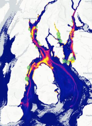
Marine & coastal
Mapping & modelling resources – phase 2
£15,000 awarded
There is a long history of fish farms on the West Coast & the fin fish industry has declared its aim to double in value by 2030. 2021 catch figures for wild salmon & sea trout were the lowest ever recorded, with the most severe declines corresponding to the ‘aquaculture zone’. Phase 1 of this project developed hydro-dynamic modelling of the West Coast & Hebrides in-shore waters to illustrate the cumulative risk sea lice larvae from multiple fish farms can create for wild fish producing user-friendly heat-maps which could be used to challenge fish farm applications for expansion or to establish new farms. This grant for phase 2 will validate the sea lice models & develop models for particulate waste & dissolved nutrients (2 other types of pollutants discharged by fish farms into the surrounding sea which can lead to harmful planktonic blooms, potentially endangering marine life but also people (eg swimmers, water-sports, etc)).